How to Read a Map: A Practical Beginner’s Guide
This post may contain affiliate links. Read my full disclosure here.
Most people carry a GPS in their pocket, but surprisingly few people know how to read a map.
That’s not a problem until technology stops working. A dead battery, poor cell service, severe weather, or a major emergency can quickly turn a routine trip into a stressful situation. Knowing how to read a map gives you a reliable backup that works anywhere.
The good news is that map reading isn’t complicated. Once you understand a few basic concepts, you’ll be able to use road maps, topographic maps, and other types of maps with confidence.
Whether you’re preparing for emergencies, planning a road trip, hiking in the backcountry, or simply wanting to be more self-reliant, learning this skill is well worth the effort.
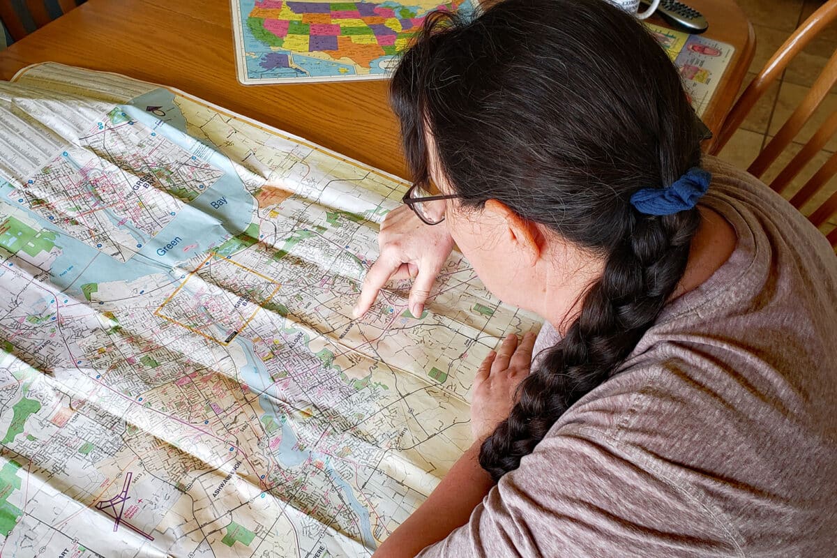
Table of Contents
Why Learn How to Read a Map?
Maps help us understand where we are, where we want to go, and what lies between.
Digital navigation systems do much of the thinking for us, but they don’t always show the bigger picture. A paper map lets you see alternate routes, nearby towns, rivers, terrain features, and other details that may not be obvious on a phone screen.
Map reading is especially valuable for:
- Emergency preparedness
- Evacuation planning
- Road trips
- Hiking and camping
- Hunting and fishing
- Exploring unfamiliar areas
- Rural living
A paper map never needs charging and works even when communication networks are unavailable. We keep them on hand for traveling where cell service is spotty. We also taught our sons how to read a map as part of the homeschooling curriculum.
When my boys were still quite young, I was helping an older neighbor child with math homework. As we were working, she spotted our wall maps. She noted that she hadn’t realized that Alaska was part of the North American continent, because she’d only seen maps where it was shown detached.
After that, I added even more maps to our home. Geography is a primary force that shapes past, current, and future events. Without perspective, we limit our understanding.
The Basic Parts of a Map
Although there are many different types of maps, most contain the same core elements.
Title
The title tells you what area the map covers and often indicates its purpose.
Examples include:
- Wisconsin State Highway Map
- Kewaunee County Road Map
- Yellowstone National Park Trail Map
- Topographic Map of Door County
Always verify that you’re using the correct map for your location.
Scale
Map scale shows the relationship between distances on the map and distances in the real world.
For example:
- 1 inch = 1 mile
- 1 inch = 5 miles
A larger-scale map shows more detail over a smaller area. A smaller-scale map shows a larger region but with less detail.
The scale allows you to estimate travel distances and compare routes.
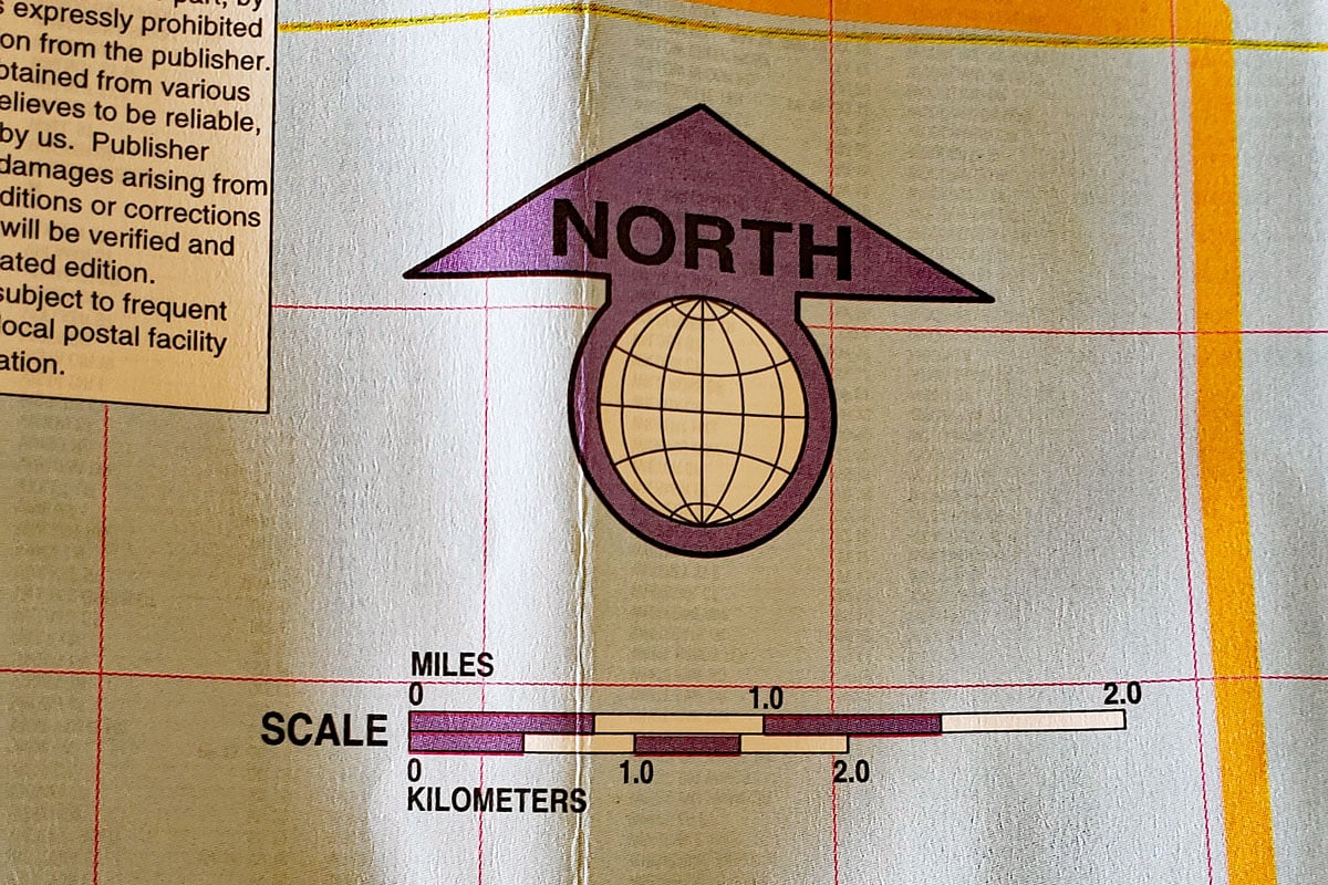
Compass Rose
Most maps include a compass rose showing direction.
The four primary directions are:
- North
- South
- East
- West
Many maps also show intermediate directions:
- Northeast
- Southeast
- Southwest
- Northwest
Before planning a route, orient yourself so you understand which direction you’re traveling.
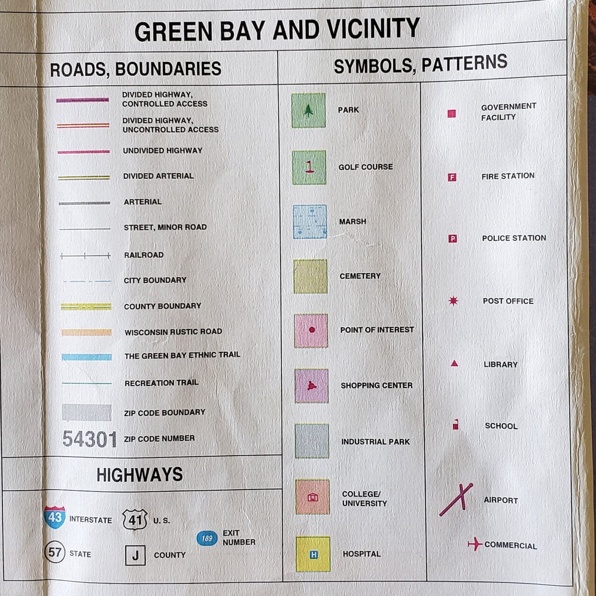
Map Legend
The map legend is one of the most important parts of any map. A map legend explains what the symbols, colors, and lines mean.
Common symbols include:
- Highways
- Secondary roads
- Railroads
- Airports
- Campgrounds
- Hospitals
- Parks
- Rivers and lakes
If you encounter a symbol you don’t recognize, check the map legend before making assumptions. Think of the legend as the map’s translation guide.
Understanding Road Maps
Road maps are the most common maps people use. They are designed to help drivers navigate highways, roads, and communities.
Road maps typically show:
- Interstate highways
- State highways
- County roads
- Cities and towns
- Parks
- Rest areas
- Airports
- Bodies of water
When using road maps, start by locating your current position and destination.
Next:
- Identify major highways.
- Look for alternate routes.
- Estimate travel distances using the scale.
- Note fuel stops and larger communities along the way.
Preparedness-minded families should identify at least three routes to important destinations whenever possible.
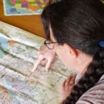
When I was learning to navigate around the Green Bay area (back before GPS was common), I used the main highways as my reference points. Since there’s a big highway on all four sides of the city, I knew that even if I got lost, I would eventually hit a highway. Then I could navigate from there.
As a person who grew up 10 miles out of a town of only 315 people, it was a big change to live near a metro area of around 300,000 people. (Yes, I did sometimes have the steering wheel in a death grip as I made my way around. Now it’s much more familiar.)
We keep road maps in the glove compartment, in our roadside emergency kits and winter car kits.
Types of Maps and Their Uses
Not all maps serve the same purpose. Understanding different types of maps helps you choose the right tool for the job.
Road Maps
Best for:
- Vehicle travel
- Evacuation planning
- Long-distance trips
- Route comparisons
As you would expect, road maps focus primarily on transportation networks.
Topographic Maps
Topographic maps show terrain and elevation. They use contour lines to represent hills, valleys, ridges, and other landforms.
Would you like to save this?
These maps are useful for:
- Hiking
- Hunting
- Rural properties
- Search and rescue
- Land management
Topographic maps reveal information that road maps often omit. We downloaded one of our property when Duncan was working on his permaculture design certification.
Trail Maps
Trail maps focus on recreational areas.
They often show:
- Hiking trails
- Campgrounds
- Water sources
- Scenic overlooks
- Park facilities
Political Maps
Political maps emphasize boundaries.
These may include:
- Countries
- States
- Counties
- Municipal boundaries
We have wall maps and placemats like this.
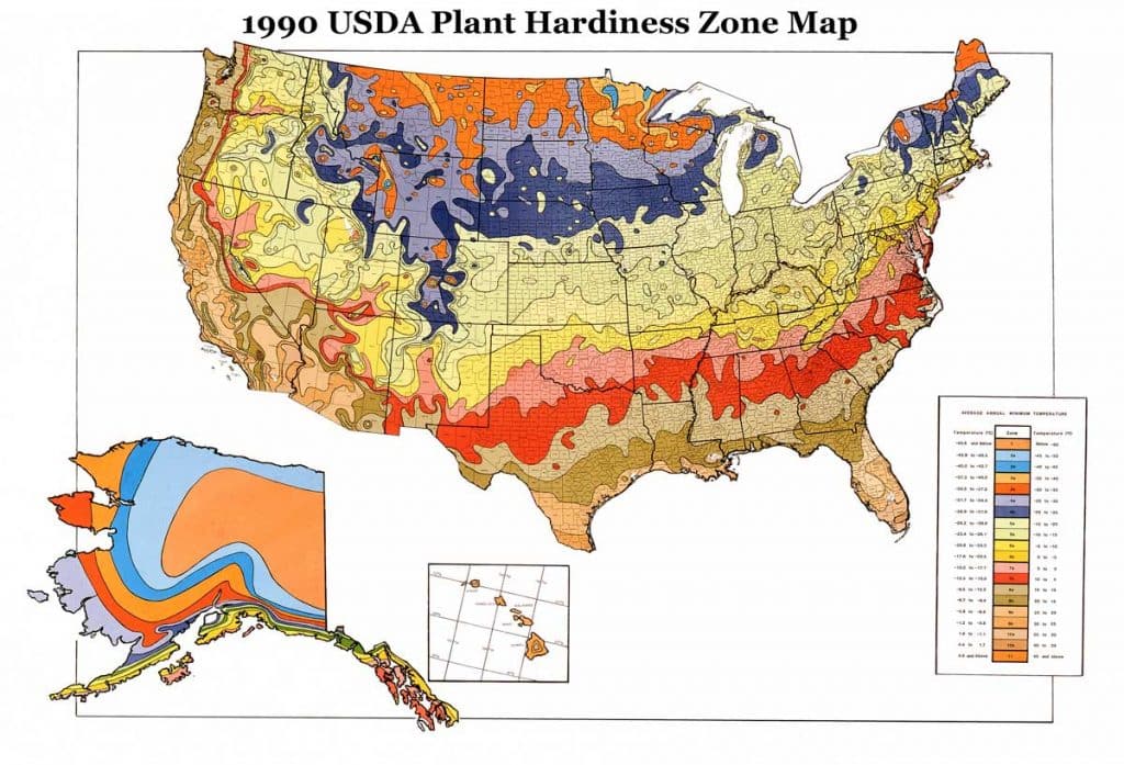
Weather Maps and Hardiness Zone Maps
Weather maps help track storms and changing conditions. They’re commonly used by meteorologists, emergency managers, farmers, and travelers. I check our local weather map daily, especially when I’m planning outside work.
Hardiness zone maps are used for gardening to help estimate growing conditions. These shift over time, so it’s good to compare current and historic maps. Local microclimates will also impact your growing conditions.
How to Read Distance on a Map
One of the most useful map-reading skills is estimating distance.
First, locate the map scale. Then:
- Measure the route using a ruler, string, or even a strip of paper.
- Compare that measurement to the scale.
- Calculate the real-world distance.
For example, if one inch equals five miles and your route measures four inches, the trip is approximately twenty miles. Remember that travel time depends on more than distance. Road conditions, traffic, weather, and terrain all affect how quickly you can travel.
I was talking to a friend about this recently as we were looking for Azure Standard drops near her mountain home. Though the nearest drop looked fairly close on the map, the winding mountain roads meant it was close to an hour drive. By contrast, our closest drop is about 10 minutes nearly straight north over gently rolling farmland. It’s a much easier drive.
Understanding Topographic Maps
Topographic maps deserve special attention because many people find them intimidating. (I think they are really cool, like lacy artwork.)
The basic concept is simple. Topographic maps use contour lines to show changes in elevation.
Contour Lines
A contour line connects points of equal elevation.
When contour lines are:
- Far apart = gentle slopes
- Close together = steep terrain
The closer the lines, the steeper the landscape.
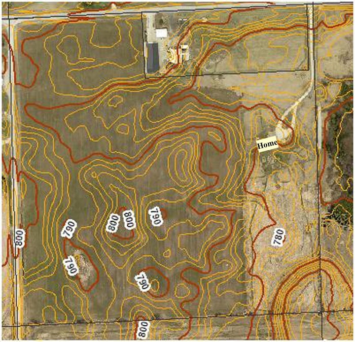
Elevation Markings
Many contour lines are labeled with elevation values.
These numbers help you determine:
- Hilltops
- Valleys
- Ridges
- Drainage areas
For preparedness planning, this information can be useful when evaluating flood risk, water sources, travel routes, and potential shelter locations.
How to Orient a Map
A map is most useful when it matches the direction you’re facing.
To orient a map:
- Determine north using a compass, the sun, or known landmarks.
- Rotate the map until north on the map points north in the real world.
- Compare roads, rivers, and landmarks around you to those shown on the map.
This simple step makes navigation much easier.
Practice Before You Need It
Map reading is a practical skill that improves with use.
Try these simple exercises:
- Follow a paper map during your next road trip.
- Mark alternate routes to work or family members’ homes.
- Locate local parks, hospitals, and emergency shelters.
- Identify potential flood zones or bottlenecks near your community.
- Compare your paper map to your GPS to see what each reveals.
The more often you use maps, the more comfortable you’ll become. You may even discover some hidden treasures in your area that the GPS ignored.
Build a Family Preparedness Map Kit
If you’ve already read our guide on paper maps, the next step is putting those maps to work.
Consider creating a preparedness map kit that includes:
- Local road maps
- State maps
- Regional maps
- Topographic maps
- Emergency contact information
- Meeting locations
- Evacuation routes
Store the kit in a waterproof folder or binder where it can be accessed quickly.
See “Paper Maps for Preparedness: What to Buy and Why” to help guide your purchase.
Map Reading Matters
Learning how to read a map is one of those old-fashioned skills that remains useful. Maps help you understand your surroundings, plan safer routes, and make informed decisions when circumstances change. They also provide a dependable backup when electronic navigation systems are unavailable.
You don’t need to become an expert cartographer. Simply understanding a map legend, recognizing different types of maps, and learning to estimate distance will put you ahead of most people.
Map reading also expands your systems thinking. Instead of focusing only on the next turn, you begin to see how roads, terrain, waterways, and communities connect. That broader perspective helps you make better decisions, whether you’re planning a road trip, navigating an emergency, or building a more resilient life.
Like many traditional skills, map reading isn’t just about finding your way. It’s about learning to see the bigger picture.

This article was written by Laurie Neverman. Laurie is the creator of Common Sense Home, and author of Common Sense Preparedness. She and her family live in northeast Wisconsin in their ICF home, which they jokingly refer to as their “concrete bunker”. They use three types of solar and have extensive gardens and food forests.